The Darling River, Outback NSW
The Darling River is Australia's most iconic river and its longest waterway when measured from its farthest tributary. It stretches over 2,739 km from Queensland's Darling Downs across Outback NSW to its confluence with the Murray River at Wentworth, draining approximately 14% of Australia's total landmass as part of the Murray–Darling Basin.
The Darling River holds the title of Australia's most iconic river, boasting the distinction of being the country's longest waterway when combined with its longest tributaries. It stretches from Queensland's Darling Downs, traversing Outback NSW, until it meets the Murray River at Wentworth in the southwest corner of New South Wales.
Exploring the Darling River
To truly appreciate the grandeur of Australia's greatest waterway, there is one captivating journey to embark upon: the Darling River Run and the Source to Sea touring route, which covers the entire length of the river.
A Vital Part of the Murray–Darling Basin
The Darling River is a vital component of the Murray–Darling Basin, an extensive area spanning 1,061,469 square kilometres, covering approximately 14% of Australia's total landmass. Originating from Queensland's Darling Downs and the northern rivers region of New South Wales, the Darling River catchment shares borders with the Lake Eyre Basin's Lake Frome division, just north of Broken Hill and south of Cameron Corner. Surprisingly, the opal town of White Cliffs also falls within the Darling River catchment.
To gain insights into the region's captivating geology and hydrography, embark on the Watershed Loop touring route. This route not only connects the Darling River Run with other Corner Country touring routes but also provides a profound understanding of the land's formation and water flow.
Nature's Contrasts: Boom and Bust
While the Murray River receives its flow from the snowmelt in the New South Wales and Victorian alpine regions, the Darling River primarily relies on subtropical summer rains in the Darling Downs of South East Queensland. This fundamental difference gives the Darling River its distinctive boom and bust characteristics regarding its water flow.
The Darling River has always been marked by extremes, with periods of both floods and droughts. This inherent nature contributes to the ethereal majesty of our most iconic river. Flowing southwest across outback New South Wales, the Darling River eventually merges with the Murray River at Wentworth, situated on the New South Wales/Victoria border. From there, it meanders through South Australia's Riverland region, ultimately reaching Lake Alexandrina and finally the Southern Ocean.
The Indigenous Darling River (Baaka)
A Cultural Legacy Spanning Millennia
The Indigenous people, known as the Barkintji, have an extensive and living cultural connection with the Darling River, which they refer to as the Barka. Evidence suggests that their history along the river dates back over 45,000 years. To this day, the river remains the lifeblood of their rich cultural heritage.
The Indigenous cultures have left profound imprints along the length of the river, with notable sites such as the fish traps at Brewarrina and the world's oldest ritual burial ground at Lake Mungo. These sites, along with countless others, bear witness to the river's historical and sacred significance. For centuries, the river has provided a home, a fishing and hunting ground, and a trade route for Aboriginal groups.
The European Darling River
Explorers, Pioneers, and River Transport
European explorers arrived in the Darling River region with the hope of discovering the fabled "inland sea," mistakenly believing that all the rivers in eastern Australia flowed into a vast, interconnected body of water. While they were correct in their assumption about the presence of an inland sea, it existed around 50 million years earlier, during the Cretaceous period when Australia's centre was submerged.
During the 19th century, the "Wild West" became a frontier for European settlement. Cattlemen established vast stations and forged stock routes connecting major commercial centres like Adelaide, Sydney, and Melbourne. However, they faced the challenge of establishing reliable road transport to access these service centres. Many believed that river transport could revolutionise the outback, providing a vital link from the farm gate to shipping ports in Adelaide and Melbourne, thus enabling transportation to England.
The dream of river transport began to materialise in 1859 when a riverboat named Gemini, captained by William Randell, successfully navigated the Darling River, reaching Brewarrina (formerly known as "Walcha Hut" and earlier as "Fishery"). This milestone confirmed the river's potential as a significant transportation route.
By the 1890s, river ports in Bourke, Wilcannia, and Wentworth were bustling, catering to the vast wool empires of Outback NSW and southern Queensland, which spanned over a million hectares. Wentworth, in particular, emerged as Australia's busiest inland port by the late 1880s. In 1895 alone, 485 vessels passed through the Customs House, with 31 vessels in a single week.
However, challenges arose due to the boom and bust nature of the river's flow, and the advent of railways in the early 1900s provided a more reliable means of transport. Consequently, the relevance of riverboats and ports began to decline.
Today's Darling River: A Precious Resource
The Darling River retains its integral role in the outback, indigenous culture, and pioneering history. Efforts are underway to better manage this invaluable resource, ensuring its availability for farmers, indigenous communities, and recreational enjoyment.
Environmental Challenges and Resilience
In 1992, the Darling River faced a severe crisis as cyanobacterial blooms, stretching the entire length of the river, occurred. These toxic algae blooms were fuelled by the presence of phosphorus, while other contributing factors included flow rates, turbulence, turbidity, and temperature.
In 2008, the Australian government purchased Toorale Station in northern New South Wales for A$23 million, allowing for the return of eleven gigalitres of environmental flows into the Darling River.
In 2019, the Darling River once again made headlines when up to one million fish perished due to the drought and lack of flowing water, which stagnated the remaining water at Menindee Lakes. The 2019 drought was comparable to the severe Federation drought that occurred in the early 1900s, which stands as the most devastating drought in recorded history.
However, in March 2020, eastern Australia experienced a remarkable deluge of rain, offering respite from the drought and replenishing the Darling River and surrounding areas. This rainfall event was considered one of the most significant and comprehensive in living memory.
By late 2022, the Murray–Darling Basin had undergone a reboot, with the long and harsh drought finally becoming part of history for most of the region.
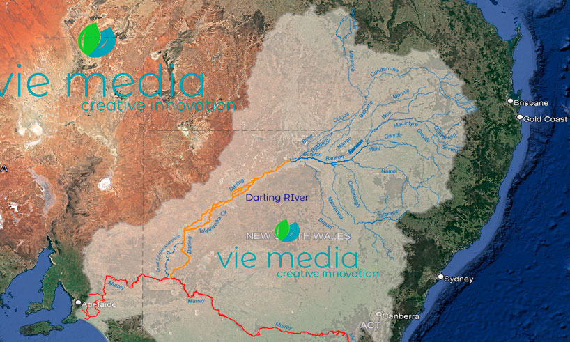
Darling River Course & Geology
A Magnificent River System
As one of the largest river systems globally, the Murray–Darling Basin drains extensive regions, including all of New South Wales west of the Great Dividing Range, most of Victoria north of the Great Dividing Range, southeast Queensland, and southeast South Australia. The Murray–Darling Basin encompasses nearly 15% of Australia's total land area, spanning 1,062,025 square kilometres.
Measuring from its longest tributary to its mouth at Wentworth, the Darling River stretches over 2,739 kilometres, solidifying its position as Australia's longest waterway. Its course flows via the Condamine–Balonne Catchment, with the Condamine River originating near Killarney in Queensland. The Condamine River is joined by the Balonne River and the Culgoa channel before merging with the Darling River upstream of Bourke.
Other Catchments Within the Darling River Basin
- Paroo Catchment
- Warrego Catchment
- Moonie Catchment
- Border Rivers Catchment
- Namoi Catchment
- Macquarie–Castlereagh Catchment
The Darling River catchment features relatively flat terrain, with a gradient of only 16 millimetres per 1,000 metres. The river proper begins between Brewarrina and Bourke at the confluence of the Culgoa and Barwon rivers.
It's important to note that the Darling River is not an unregulated river. In 1949, the Menindee Lakes system was created through the conversion of natural lakes around Menindee, known as the Laidley Pondage. This system serves as the primary river regulation mechanism. Originally, the pondage consisted of a series of shallow ephemeral freshwater lakes connected to the Darling River, forming a storage system that allowed for controlled flows.
For more information about the Darling River, its tributaries, map, history, and the significance of the river to Indigenous cultures, please explore the following sections:
- Darling River Tributaries
- Darling River Map
- Darling River History
- The Indigenous Darling River (Baaka)
We invite you to discover the rich heritage, natural wonders, and ongoing efforts to preserve and protect Australia's iconic Darling River.
Frequently Asked Questions
How long is the Darling River?
Measured from its longest tributary, the Darling River stretches over 2,739 kilometres, making it Australia's longest waterway. It flows from Queensland's Darling Downs through Outback NSW to its confluence with the Murray River at Wentworth.
What is the Darling River called by Indigenous people?
The Darling River is known as the Barka (or Baaka) by the Barkintji people, the traditional custodians of the Lower Darling region. Indigenous history along the river dates back over 45,000 years, and the river remains central to Barkintji culture and Dreaming stories today.
What is the Murray–Darling Basin?
The Murray–Darling Basin is one of Australia's most significant river systems, spanning approximately 1,062,025 square kilometres — around 14–15% of Australia's total land area. It drains all of NSW west of the Great Dividing Range, most of Victoria's north, southeast Queensland, and southeast South Australia.
Why does the Darling River have a boom and bust flow pattern?
Unlike the Murray River (fed by alpine snowmelt), the Darling relies primarily on subtropical summer rains from Queensland's Darling Downs. This means flows are unpredictable — the river swings from drought to flood roughly every seven years, giving it its distinctive boom and bust character.
Where does the Darling River start and end?
The Darling River proper begins between Brewarrina and Bourke at the confluence of the Culgoa and Barwon rivers, though its longest source tributary (the Condamine) rises near Killarney in Queensland. The river ends at Wentworth, NSW, where it meets the Murray River.
Explore the Darling River
From its headwaters in Queensland to the Murray junction at Wentworth, the Darling is one of Australia's great natural and cultural treasures. Plan your own journey with the complete touring guide, or browse outback imagery from the river.