Darling River Map and Touring Guide
This interactive Google Map traces the Darling River's course from upstream of Brewarrina through Bourke, Louth, Tilpa, Wilcannia, and Menindee Lakes to its junction with the Murray River at Wentworth — giving a clear picture of how the river fits within the larger Murray–Darling Basin and how to plan a Darling River Run itinerary.
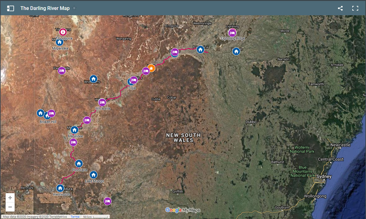
A map of the Darling River helps understand its part in the larger Murray–Darling Basin — from the geography of southeast Australia to the tributaries that flow into the Darling River. It also provides a means to plan trips along the river, including The Darling River Run as well as touring routes that traverse Outback NSW in all directions.
The map below (plotted on Google Maps) shows an indicative path of the river's course from upstream of Brewarrina, across Outback NSW, through Menindee Lakes, and to where it joins the Murray River at Wentworth.
Interactive Darling River Map
For notes on the route and itinerary, please see the Suggested Darling River Run Itinerary page.
Using the Map to Plan Your Trip
Understanding the Geography
The Darling River map reveals how this iconic waterway connects the subtropical catchments of southern Queensland to the Murray–Darling junction at Wentworth. Key towns along the route — Bourke, Louth, Tilpa, Wilcannia, Menindee — are all visible, giving a clear sense of the distances involved and the remote nature of the country between them.
Tributaries and Basin
The map helps visualise how the Darling's major tributaries — the Barwon, Culgoa, Warrego, Paroo, Namoi, Macquarie, and Castlereagh rivers — feed into the main channel, making the Murray–Darling Basin one of the world's most significant inland drainage systems.
Touring Routes
Beyond the Darling River Run, the map provides context for connecting touring routes across Outback NSW, including the Silver City Highway, the Corner Country loops via Tibooburra and Cameron Corner, and the Watershed Loop that crosses the divide between the Darling Basin and the Lake Eyre Basin.
Frequently Asked Questions
Where does the Darling River run on a map?
The Darling River runs in a generally southwest direction across Outback NSW, beginning between Brewarrina and Bourke (where the Barwon and Culgoa rivers merge), passing through Bourke, Louth, Tilpa, Wilcannia, and Menindee, before joining the Murray River at Wentworth on the NSW–Victoria border.
How do I open the full interactive Darling River map?
Click the map image at the top of this page or the embedded map below to open the full Google My Maps version. From there you can zoom in on individual towns and stations, and switch between map and satellite views.
Does the Darling River map cover the Darling River Run route?
Yes. The map traces the course of the Darling River from upstream of Brewarrina all the way to Wentworth — the full length of the Darling River Run. For turn-by-turn day-by-day route details, see the Darling River Run itinerary page.
Plan Your Darling River Journey
Map in hand, the next step is the detailed itinerary — 13 days of river country, outback towns, and wide open skies.