Tom Groggin Station, Upper Murray River
Victorian High Country Adventures — Home of the Man from Snowy River
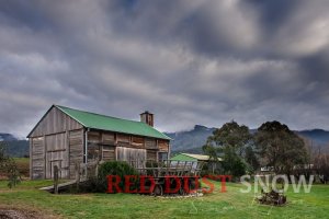
Tom Groggin Station is an 810-hectare (2,000-acre) working cattle property on the Victorian side of the Upper Murray River, set at the furthest point upstream one can drive to on a public road. Operating continuously since the mid-1800s, it is historically tied to Jack Riley — widely regarded as the real-life inspiration for Banjo Paterson's immortal poem The Man from Snowy River — and today offers self-contained cabin accommodation for couples and larger groups in one of the most beautiful parts of Australia.
"There was movement at the station, for the word had passed around..." So starts the iconic Australian poem by Banjo Paterson about a man from the Snowy River who became a legend after he recaptured a prizewinning racehorse that fled his owner's property and joined up with a group of brumbies in the High Country; that man, reputedly, was Jack Riley. So what of this man, the region and the Snowy River? Time to do a bit of High Country exploring.
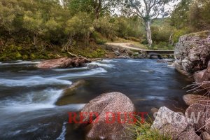
There is a place in the foothills of the Snowy Mountains that is set beautifully alongside the Murray River, and it is a place that Jack Riley worked. That place is called Tom Groggin Station.
Tom Who? — The Name and the Place
But who was Tom Groggin? Actually, there was no person called Tom Groggin, as many believe, but the name is a transliteration of an old Aboriginal word, 'tomarogin', that referred to a water spider that lived in the upper reaches of the Murray River.
The area around Tom Groggin is synonymous with adventure as it is the furthest point upstream of the Murray River one can drive to on a public (gazetted) road. It is also the point known to the more extreme off-roaders for crossing the river to access the 4WD tracks of the Victorian High Country.
While very cold in winter, it is a bit of a mecca in summer with large family-friendly campgrounds right beside the Murray River.
As well as the campground on the NSW side, there is also a wonderful accommodation option across the river a few km downstream at Tom Groggin Station, on the Victorian side of the Murray. (For the trivia buffs: the NSW/Victorian border is actually the Victorian side of the river, not down the middle as many believe.)
Tom Groggin Station is an 810-hectare (2,000-acre) working cattle property that has operated continuously as a cattle station since the mid-1800s and was a place visited by Banjo Paterson as well as the place Jack Riley worked. In fact, Jack passed away in 1914 while riding a bush track from Tom Groggin to Corryong some 60 km through the High Country bush. As legend has it, Jack became the inspiration for the Man from Snowy River after Banjo visited the Station on a few occasions. It is generally accepted also that the Man in the poem was also inspired by a few others from the region, including Owen Cummins and Charlie McKechnie.
High Country Dreaming — The Route
So it's off to the Snowy Mountains I go! Heading out of Albury, I could just drive from point A to point B, but I particularly like a bit of adventure along the way, so I am taking the 'road less travelled' and have a great route in mind that will criss-cross the Towong Shire.
Heading east via Albury and across the Murray River back into Victoria. I say crossing the Murray, and while that is technically correct, the river is not immediately obvious as this is the section of the Murray River just upstream of the Hume Dam that forms the 20,000+ hectare Lake Hume.
Lake Hume and the Snowy Hydro Scheme
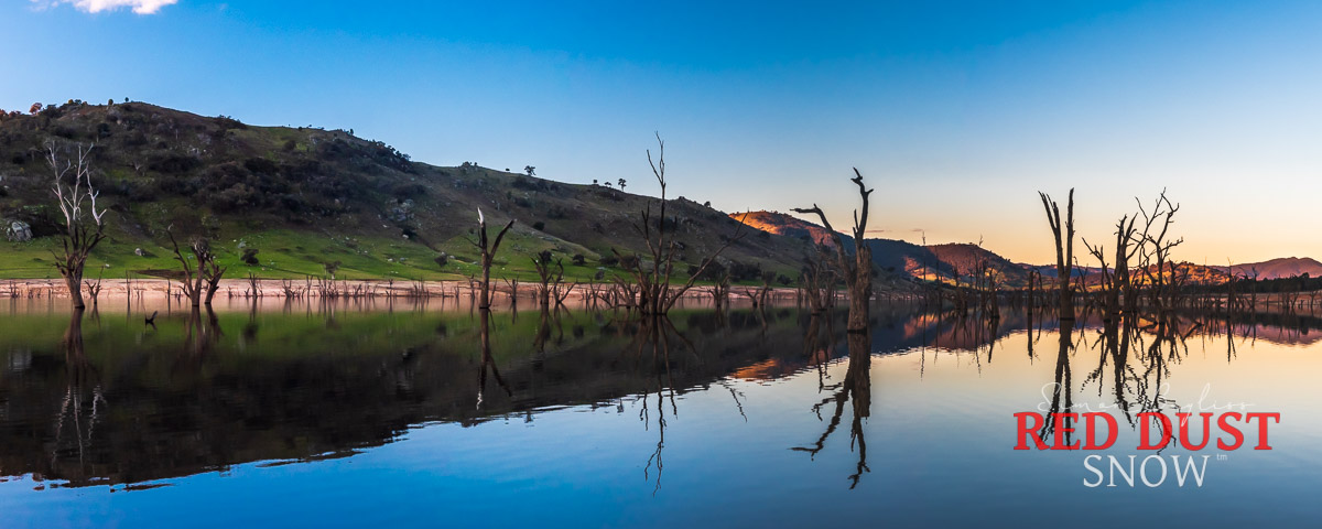
The dam, at what was the junction of the Murray and Mitta Mitta rivers, took seven years to build and when finished in 1936 was the largest dam in the southern hemisphere and one of the biggest in the world. To say it is a huge body of water is an understatement: water retained upstream through both the Murray and Mitta Mitta rivers stretches over 40 kilometres, and is a haven for water sports, fishing, and camping.
When built, the Hume Dam was designed for a 1,500 Gigalitre capacity, but this was increased to 3,005 Gigalitres in the late 1950s to capitalise on the increased water flow of the Snowy Hydro Scheme — the result of the Snowy River being tunnelled back through the Great Divide to flow west and into the Murray–Darling Basin. Simply amazing when one contemplates that engineering feat and all the migrant workers who built it. For many, their contribution to the project was the major foundation of multicultural Australia.
"Their contribution to the project was the major foundation of multicultural Australia."
Murray River Road and Tallangatta
Driving along the wonderful winding Murray River Road, I reminisce about the many times I have driven this road and the Murray Valley Road that parallels to the south along the Mitta Mitta Valley, and how often I have asked myself as I pass a certain road, "I wonder what's along there." Well, enough questioning and time to find out.
My planned route covers the Murray River Road as far as Talgarno and then south via Georges Creek Road past Mount Granya State Park and onto Tallangatta. The road up and over the ridge is a combination of bitumen and gravel and reveals some spectacular vistas of the area. The intermittent gravel roads are a nice warmup to the other tracks further along this route to Corryong.
About Tallangatta
Tallangatta, known as the town that moved, was relocated from its original position 7 km east along the Mitta Mitta River to its current location due to the rise in water levels of Lake Hume that resulted from its increased capacity when the Snowy Hydro scheme was being built in the 1950s.
When the lake is low, as it was at around 22% capacity on one of my visits, the remnants of the old town are still visible near the roadside interpretive site.
Koetong to Burrowye
Back on the road and heading east along the Murray Valley Highway to Koetong, where the adventure route continues north along Burrowye Rd, up through the pine plantations and up to the higher ground through thick native forests and wonderful trails with plenty of 'wow' moments.
The route then descends to Burrowye Creek through beautiful farming valleys before returning to the bitumen and into Burrowye, then back onto the Murray River Road.
It is here that you can see the upper Murray River in all its natural glory as a free-running river. The river around Mount Alfred and Walwa and past Gadd's Bend Camping Ground is a pleasant reminder of nature at its best.
Cudgewa Bluff Road to Corryong
With a quick 25 km along the bitumen, the route heads south from Walwa and into more amazing forest tracks with even more side tracks on offer (noted for next time as time is limited).
Heading south along Cudgewa Bluff Road, which is by far the best off-bitumen leg of the trip so far and is a must for anyone travelling through the area — a spectacular 25 km road through the Burrowa Pine Mountain National Park before joining the Cudgewa–Tintaldra Road (bitumen), not far from our next stop at Corryong. For the best vista of this town, with its backdrop against the High Country mountains, head down Briggs Gap Road. Truly spectacular!
About Corryong
Corryong is the largest town in the shire (around 1,200 people) and is the gateway to the Snowy Mountains. A great stopover service town with all amenities and a great museum featuring the history of the area, especially its association with Jack Riley and Banjo Paterson.
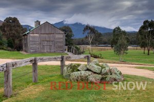
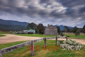
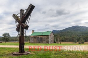
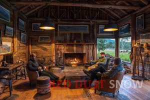
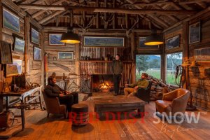
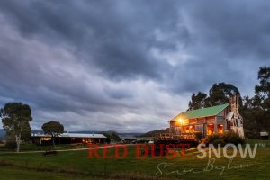
Images of Tom Groggin Station
Up to Scammells Spur and Tom Groggin
A perfect spot for a quick break and refuel before heading into the High Country and our destination at Tom Groggin, 75 km away. About 15 km out of Corryong we cross the Murray River and into NSW — there are no roads along the Victorian side of the Murray to Tom Groggin Station, so it is via the Alpine Way in NSW.
As we get closer and closer to the mountains proper, the landscape is remarkable as the small hills turn into larger ones, and the smaller we feel as the mountains loom larger and larger.
About Khancoban
The last town before the ascent up to Scammells Spur is Khancoban, a small service town that was originally built as a base for the Snowy Hydro Scheme back in the 1950s.
Arriving at Tom Groggin
The climb up to Murray 1 Power Station soon reveals the majesty of the place and the natural beauty of the High Country. Climbing further up, Scammells Lookout at 1,100 m reveals cloud and mist with visibility soon down to about 10 metres. The drive over the top features beautiful winding roads through the pristine Eucalypt forests whose heady eucalyptus scent fills the car, even in the colder months.
Visibility is soon restored as we descend below the cloud towards Geehi Plains and then onto Tom Groggin Station, which we make just on last light. The best thing about arriving as darkness envelops the valley is that morning will reveal the mountain landscape and Tom Groggin's setting.
With an open fire and cuppa on offer, there are few things better than reflecting on the day's adventure. The overwhelming feeling for me is always towards those who opened up this country before any surveyed roads, as well as those who came from post-war Europe to build the Snowy Scheme. Simply mind-boggling how they tolerated the conditions in more rudimentary structures and vehicles than we enjoy today.
Weather-wise, the next morning certainly did not disappoint as we woke to cloudy skies with the rain of yesterday gone. The majesty of the mountains was slowly being revealed.
Station Life — Accommodation & Exploring
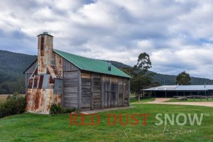
Tom Groggin Station, while well known as a location and place of history, is not as widely known for the great accommodation it offers in one of the most beautiful parts of Australia. There are two accommodation options available: the first is purely for couples (or really good friends) in a fully self-contained one-bedroom log cabin, while the other option is for larger groups in the four-bedroom, two-bathroom house with all the mod-cons.
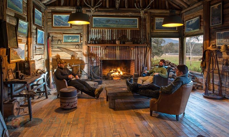
Also on offer is the use of the timber slab hut that includes a big open fireplace and bar facilities. This is an original structure — not 'made-to-look-like' — complete with old photos, paintings, equipment and memorabilia from a bygone era; an era when the likes of Jack Riley and Banjo Paterson were around. Wayne, the manager of the property, is a wealth of knowledge on the area and its history, and it is a wonderful experience to sit by the fire and hear him regale the history of the station, the people, and even the history of the hut we are sitting in. If those walls could talk.
One of the best things about the remoteness of Tom Groggin Station is that there is no phone reception, so it is truly a place to relax and enjoy. There is a station phone available for contact with the outside world. Alternatively, it is a short drive back onto the Alpine Way where mobile coverage is available for certain providers.
Olsens Lookout & Geehi Flats
With only a couple of days here, it was time to explore. Top of the list is a trip to Olsens Lookout, which provides the visitor with a spectacular view of the Main Range and some perspective on how big the mountains really are.
Olsens Lookout is reached via Geehi Dam Road (also referred to as Olsens Road), about 20 km north of Tom Groggin along the Alpine Way. Leaving the Alpine Way, it is an 11 km trip to the lookout along an unsealed but well-maintained track that basically parallels the Main Ridge and reveals a different perspective of the range at each turn. The lookout itself reveals the true majesty of the mountain range and is a worthwhile side trip.
Geehi Flats Campground
After a few hours of exploring the area, it's time to head back to Tom Groggin, but not before checking out one of the best campgrounds in the area at Geehi Flats, just off the Alpine Way. The area, very popular in the warmer months, is complete with picnic facilities, toilets, good river access, and a huge population of kangaroos.
Back at Tom Groggin, we gather in the slab hut with the fire blazing and a clear view out the window of the fading light, chatting for hours about this journey, about more adventures, about places to go, about the next road trip...
This is what an adventure is all about!
Man from Snowy River Trivia
There is a line in The Man from Snowy River poem: "There was Harrison, who made his pile when Pardon won the cup."
Most assume it was the Melbourne Cup, but Pardon never won the Melbourne Cup.
It was, in fact, the Menindee Cup.
Frequently Asked Questions
What is Tom Groggin Station?
Tom Groggin Station is an 810-hectare (2,000-acre) working cattle property on the Victorian side of the Upper Murray River that has operated continuously since the mid-1800s. It is historically associated with Jack Riley, widely regarded as the real-life inspiration for Banjo Paterson's poem The Man from Snowy River. Today it offers self-contained accommodation for couples and groups.
How do you get to Tom Groggin Station?
Tom Groggin Station is only accessible via the Alpine Way in NSW — there are no roads along the Victorian side of the Murray River to the station. From Corryong, cross the Murray into NSW and follow the Alpine Way through Khancoban and up Scammells Spur to Geehi Plains and Tom Groggin, approximately 75 km from Corryong.
What accommodation is available at Tom Groggin Station?
There are two accommodation options: a fully self-contained one-bedroom log cabin for couples, and a four-bedroom, two-bathroom house for larger groups. Both guests have access to the original timber slab hut with an open fireplace and bar.
Is Tom Groggin Station in NSW or Victoria?
The station is on the Victorian side of the Murray River. The NSW/Victorian border runs along the Victorian bank of the river — not down the middle as many believe — so although Tom Groggin Station is physically on the south (Victorian) bank, it sits exactly on the state boundary.
When is the best time to visit Tom Groggin Station?
Summer is the peak season, with large family-friendly campgrounds beside the Murray River and access to the walking trails. The station is very cold in winter. Note that Swampy Plains Creek Road (if approaching via the high-country route from Corryong) is closed in winter due to snow.
Explore the Upper Murray & High Country
Tom Groggin Station is the starting point for some extraordinary High Country adventures. Follow the Murray River from its source, or take the Sydney–Melbourne Diversion for a week-long alpine road trip.