Murray River Tributaries & Murray–Darling Basin Waterways
A Complete Guide to the Catchments, Rivers & Water Storage of Australia's Greatest Basin
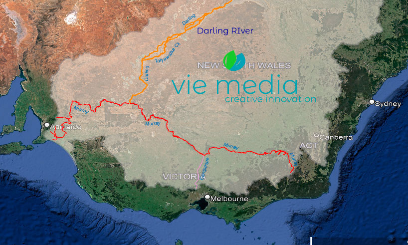
The Murray River, at 2,508 km, Australia's longest river, forms the backbone of the Murray–Darling Basin — a network of over 77,000 km of waterways covering 1,062,025 km² (nearly 15% of Australia). Its tributaries are grouped into three catchment sections: the Upper Murray (alpine rivers feeding Hume Dam), the Central Murray (including the Murrumbidgee, Lachlan, Ovens, Goulburn, Campaspe, and Loddon–Avoca rivers), and the Lower Murray (flowing west through South Australia to Lake Alexandrina and the sea).
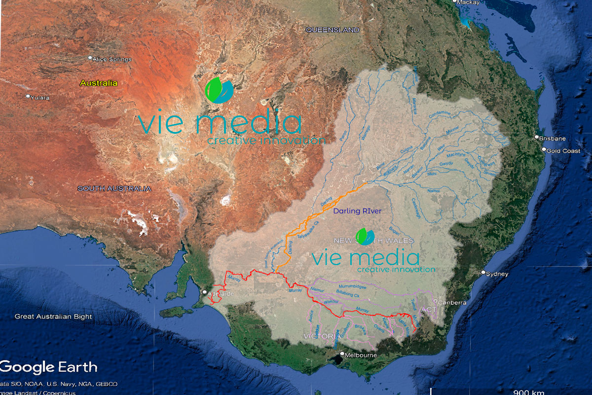
Murray River Tributaries — The Murray–Darling Basin river system consists of several main tributaries. The Upper Murray waterways are sourced from Australia's Alpine Region (the Upper Murray River, Mitta Mitta River, Kiewa River, Goulburn River, Ovens River, and the Broken River), while a second group flows north from the Great Dividing Range in central/southern Victoria (Campaspe River, Loddon River, and Avoca River). To the north of the Murray River, the Murrumbidgee River flows from the ACT to join the Murray River southwest of Balranald.
The Upper Murray River
The upper River Murray catchment stretches from the Hume Dam (near Albury) to the river's source near Mount Kosciuszko (known as the Pilot), covering about 300 km.
Located in New South Wales and Victoria, the catchment covers about 2% of the Basin's area but provides about 17% of the water.
The Upper Murray catchment is mostly pristine forest, with much of it protected as National Parks and State Forests.
- Catchment area: 2% of the Murray–Darling Basin
- Contribution to Basin water: 17%
- Annual streamflow: 2,550 GL per year (Hume Dam unregulated inflow)
- River length: 300 km from the source to Hume Dam
- Major tributaries:
- Victoria: Kiewa River, Mitta Mitta River, Koetong Creek, Cudgewa Creek, Corryong Creek, Thowgla Creek
- NSW: Geehi River, Swampy Plains River, Tooma River, Tumbarumba Creek
- Major Towns:
- Corryong
- Khancoban
- Tumbarumba
- Major Water Storage:
- Hume Dam (3,005 GL)
- Khancoban Pondage (26 GL)
- Geehi Reservoir (21 GL)
- Tooma Reservoir (26 GL)
Mitta Mitta River Catchment
{accordion title="Mitta Mitta Catchment" open="false"}
With its source on the plains beneath Mount Bogong, the upper waterways of the Mitta Mitta River drain through deeply dissected forests. The main flow starts at the confluence of the Cobungra River and the Big River and travels north to the Dartmouth Dam.
The Mitta Mitta River flows into the Dartmouth Dam, the largest storage in the Basin, which can hold up to 40% of the water for the River Murray system, before the river flows north-west through the Mitta Mitta Valley, forming the south arm of the Hume Dam.
- Catchment area: 0.9% of the Murray–Darling Basin
- Contribution to Basin water: 10%
- Annual streamflow: 900 GL (Wagga Wagga)
- River length: 204 km
- Towns:
- Dartmouth
- Eskdale
- Mitta Mitta
- Water Storage:
- Dartmouth (3,856 GL)
Kiewa River Catchment
{accordion title="Kiewa River Catchment"}

Originating below Mount Beauty, the Kiewa River forms on a narrow flood plain and flows northwards through farmland in a widening valley towards the River Murray.
Despite being the smallest catchment in the Murray–Darling Basin, the Kiewa River's upstream branches supply water to Victoria's largest hydroelectric scheme and make a significant contribution to flows in the River Murray and for downstream agricultural irrigation.
The waterways of the Kiewa River are high-value environmental assets (native species of fish, including Mountain Galaxias and Murray cod) and contain only a few wetlands, due to agricultural development, but there are important habitat sites in the Kiewa River corridor.
- Catchment area: <0.2% of the Murray–Darling Basin
- Contribution to Basin water: —
- Annual streamflow: 689 GL (Dartmouth Dam)
- River length: 108 km
- Towns:
- Tangambalanga
- Kiewa
- Yackandandah
- Mount Beauty/Tawonga South
- Falls Creek
- Killara
- Water Storage:
- Rocky Valley Dam (28 GL)
{/accordions}
The Central Murray River
From the upstream point of the Hume Dam (about 10 km from Albury), the central Murray section covers about 1,000 km to where the Murray River meets the Darling River (the Murray–Darling Confluence) at Wentworth.
The catchment of the central Murray River covers both sides of the New South Wales and Victorian borders, and while it only accounts for around 3% of the total Murray–Darling Basin, it provides over 50% of the inflow of the basin.
Along the central sections — which take in towns like Corowa, Yarrawonga, Tocumwal, Echuca/Moama, Swan Hill, and Mildura — the Murray River is wide and flowing strongly through predominantly riverine plains on both sides.
The river also flows through the Barmah–Millewa Forest, the largest stand of River Red Gum in the world; its natural wonderment is nationally and internationally recognised.
- Catchment area: 3% of the Murray–Darling Basin
- Contribution to Basin water: —
- Annual streamflow: —
- River length: 1,200 km Hume Dam to Wentworth
- Major tributaries:
- Victoria: Ovens River, Goulburn River, Campaspe River, Loddon River, Wakool River, Broken Creek
- NSW: Murrumbidgee River
- Major Towns:
- Albury–Wodonga
- Yarrawonga
- Echuca–Moama
- Deniliquin
- Swan Hill
- Mildura
- Wentworth
- Major Water Storage:
- Yarrawonga Weir (118 GL)
- Torrumbarry Weir (37 GL)
- Mid-Murray Storage (58 GL)
- Mildura Weir (37 GL)
Murrumbidgee River Catchment
{accordion title="Kiewa River Catchment" open="false"}
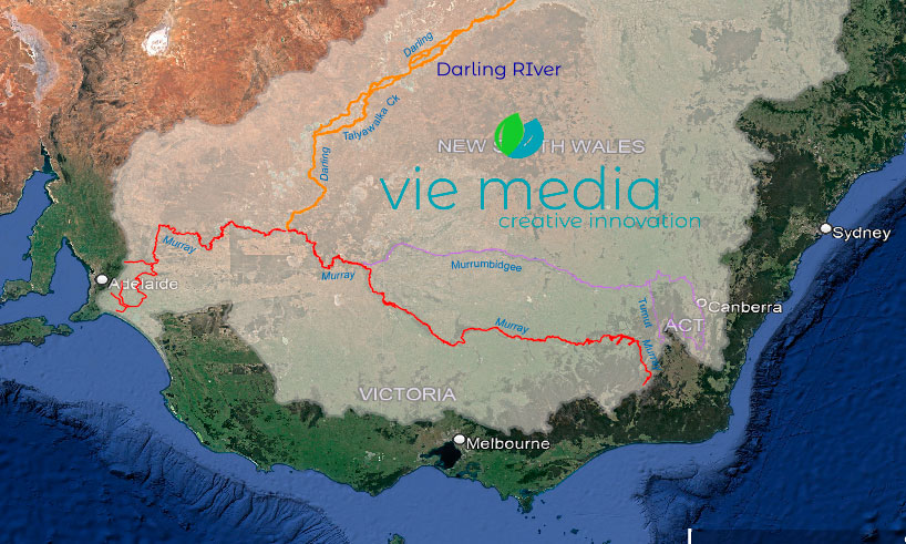
At 1,485 km, the Murrumbidgee River is Australia's third-longest river. The Murrumbidgee River catchment traverses the southern section of NSW, with the easternmost section located in the ACT.
Around 30% of the Murray–Darling Basin's population lives in the Murrumbidgee catchment, and the basin accounts for 25% of New South Wales' fruit and vegetable production, almost 50% of the State's grape production, and 50% of Australia's rice production.
The Murrumbidgee source is high up in the Australian Alps, and it joins the Murray River southwest of Balranald, travelling through a complex and diverse landscape that encompasses many wetlands and riverine environments, including the Lowbidgee wetlands and Tuckerbill and Fivebough swamps.
The Tumut River, the Murrumbidgee's largest tributary, is part of the Snowy Mountains Hydro-Electric Scheme.
- Catchment area: 8% of the Murray–Darling Basin
- Contribution to Basin water: 16%
- Annual streamflow: 4,000 GL (Wagga Wagga)
- River length: 1,485 km
- Towns:
- Cooma
- Canberra
- Yass
- Tumut
- Gundagai
- Cootamundra
- Wagga Wagga
- Narrandera
- Leeton
- Griffith
- Hay
- Queanbeyan
- Water Storage:
- Burrinjuck (1,026 GL)
- Blowering (1,628 GL)
- Talbingo (921 GL)
- Tantangara (254 GL)
- Googong (125 GL)
Lachlan River Catchment
{accordion title="Lachlan River Catchment"}
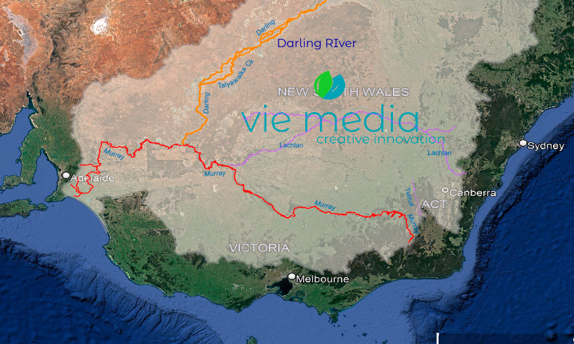
The Lachlan River, at 1,339 km, is Australia's fourth longest river, rising on the Breadalbane Plain between Yass and Goulburn, west of the Great Dividing Range. The waterway travels westward through undulating country before crossing the river plains of the central catchment.
When conditions are right — during high flows — water will flow south through the Great Cumbung Swamp and reach the floodwaters of the Murrumbidgee River.
- Catchment area: 8% of the Murray–Darling Basin
- Contribution to Basin water: 6.5%
- Annual streamflow: 834 GL (Cowra)
- River length: 1,339 km
- Towns:
- Boorowa
- Cowra
- Canowindra
- Forbes
- Hillston
- Water Storage:
- Wyangala (1,220 GL)
- Lake Cargelligo (36 GL)
- Carcoar Dam (36 GL)
Ovens River Catchment
{accordion title="Ovens River Catchment"}

The Ovens River, which joins the Murray River near Lake Mulwala, flows through a diverse landscape, starting with the steep, forested mountains of the Victorian Alps and ending in the wide valleys and open plains on its northerly journey.
The Ovens River is significant for its diverse aquatic habitats and is home to a range of threatened species, including the Murray cod and the Murray spiny crayfish.
The region contains several nationally significant wetlands extending from the confluence of the Ovens and King rivers to Lake Mulwala.
Downstream of Wangaratta, the river and its floodplain support native fish habitats and an ibis breeding site. The area is also home to a flora reserve and the Lower Ovens Wildlife Reserve.
- Catchment area: 0.7% of the Murray–Darling Basin
- Contribution to Basin water: 6%
- Annual streamflow: 1,775 GL (at Peechelba)
- River length: 109 km
- Towns:
- Bright
- Beechworth
- Myrtleford
- Wangaratta
- Water Storage:
- Lake Buffalo (24 GL)
- Lake William Hovell (14 GL)
Goulburn & Broken Rivers Catchment
{accordion title="Goulburn & Broken Rivers Catchment"}

With their headwaters rising in the Great Dividing Range, south of Lake Eildon, the Goulburn and Broken rivers are the most southerly of all rivers of the Basin, with many of the waterways flowing into the two rivers in the highlands of northern Victoria.
Fed by high rainfall and spring snowmelt, the Goulburn and Broken rivers contribute about 1/10 of the Murray–Darling Basin's water, with the Goulburn being the largest tributary to the Murray River and also the most regulated, due mostly to its urban and agricultural use.
- Catchment area: 2% of the Murray–Darling Basin
- Contribution to Basin water: 11%
- Annual streamflow: 3,000 GL (Wagga Wagga)
- River length: Goulburn River: 570 km, Broken River: 174 km
- Towns:
- Shepparton
- Kyabram
- Benalla
- Seymour
- Mansfield
- Water Storage:
- Goulburn River: Lake Eildon (3,334 GL), Goulburn Weir (26 GL), Waranga Basin (432 GL), Greens Lake (33 GL)
- Broken River: Lake Nillahcootie (40 GL)
Campaspe River Catchment
{accordion title="Campaspe River Catchment"}
Rising from wooded, hilly terrain, the Campaspe is typical of many waterways in the southern Murray–Darling Basin, descending from the foothills of the Great Dividing Range and emerging onto the wide, flat, riverine plains of northern Victoria.
Along with its main tributary, the Coliban River, the Campaspe River is highly regulated, with only limited natural flows. But environmental releases into the system are crucial to maintaining several threatened vegetation communities, aquatic life, and habitats for many terrestrial species, such as the threatened swift parrot and squirrel glider.
Accounting for around 2% of the total population of the Murray–Darling Basin, the Campaspe catchment supports dry-land agriculture in addition to dairying on the lower plains.
- Catchment area: 0.4% of the Murray–Darling Basin
- Contribution to Basin water: 0.9%
- Annual streamflow: 352 GL
- River length: 220 km
- Towns:
- Kyneton
- Rochester
- Echuca
- Water Storage:
- On the Campaspe: Lake Eppalock (304 GL)
- On the Coliban: Malmsbury (18 GL), Lauriston (20 GL), Upper Coliban (32 GL)
Loddon–Avoca River Catchment
{accordion title="Loddon-Avoca River Catchment"}

Similar to the Campaspe River, the Loddon and Avoca rivers rise in the Great Dividing Range in southern Victoria. Through wooded hilly terrain, the rivers descend northward via undulating foothills and emerge onto the plains of northern Victoria.
While not a large contributor to the Murray River, the Loddon and Avoca rivers are a significant water source for important wetlands in northern Victoria, such as the Boort District Wetlands and the Kerang Lakes.
Home to less than 10% of the population of the Basin, the Loddon and Avoca catchment is home to Victoria's fourth-largest city, Bendigo, with the main land use being dry-land cropping and grazing.
About 75% of the water used in the catchment is transferred in from other catchments, with urban water for Bendigo supplied from the Campaspe River catchment, and irrigation areas in the north supplied mainly by the Goulburn and Murray catchments.
- Catchment area: 2.3% of the Murray–Darling Basin
- Contribution to Basin water: 1.6%
- Annual streamflow:
- Loddon River: 201 GL (Laanecoorie Weir)
- Avoca River: 84 GL (Coonooer Bridge)
- River length:
- Loddon River: 310 km
- Avoca River: 270 km
- Towns:
- Bendigo
- Maryborough
- Castlemaine
- Kerang
- Avoca
- St Arnaud
- Charlton
- Sea Lake
- Water Storage:
- Loddon River: Cairn Curran Reservoir (147 GL), Tullaroop Reservoir (73 GL), Laanecoorie Reservoir (8 GL)
- Avoca River: None
{/accordions}
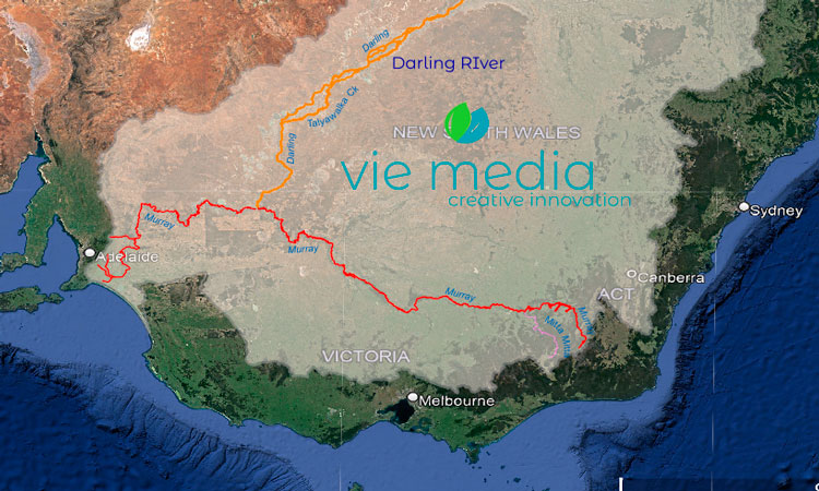
The Lower Murray River
Stretching its way to Lake Alexandrina and the Coorong, the Murray River continues its journey west before turning south at Morgan, through the semi-arid landscape of the lower Murray River catchment.
Due to the semi-arid nature of this section, little water is contributed by the surrounding catchment, but it is probably among the most spectacular scenery the river flows through, with the sandstone cliffs synonymous with the region.
The lower Murray River catchment is sparsely populated, except for some wonderful medium-sized towns that serve as hubs for diverse horticultural enterprises that complement dry-land agriculture. Tourism centred on the river environment, and water-based activities, is also important to the regional economy.
- Catchment area: 9% of the Murray–Darling Basin
- Contribution to Basin water: —
- Annual streamflow: —
- River length: 1,000 km, Wentworth – Southern Ocean
- Major tributaries:
- South Australia: Chowilla Creek, Pike River, Katarapko Creek, Marne River, Saunders Creek, Bremer River, Finnis River
- NSW: Darling River, Great Darling Anabranch, Rufus River
- Major Towns:
- Renmark
- Waikerie
- Murray Bridge
- Major Water Storage:
- Lake Victoria (677 GL)
Darling River Catchment
The Darling river system consists of over ten tributaries, with the Upper Darling River (Barwon-Darling) being a complex waterway comprising many individually named tributaries. The Barwon-Darling covers about 13% of the Murray–Darling Basin but only accounts for about 2.8% of the flow in the Basin. However, much more water flows through the system, with 99% of its flow generated via the upstream catchments.
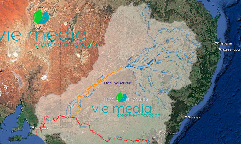
For more information on the Darling River catchment, please refer to the Darling River tributaries section.
Frequently Asked Questions
How long is the Murray River?
The Murray River is 2,508 km long, making it Australia's longest river. It flows from near Mount Kosciuszko through the Murray–Darling Basin to Lake Alexandrina and the Southern Ocean in South Australia.
What is the Murray–Darling Basin?
The Murray–Darling Basin is a network of over 77,000 km of waterways covering 1,062,025 km² — nearly 15% of Australia's total landmass. It encompasses dozens of rivers and tributaries across NSW, Victoria, Queensland, South Australia, and the ACT.
Which is the largest tributary of the Murray River?
The Darling River (joining at Wentworth, NSW) is the most significant tributary by length. Among the southern tributaries, the Goulburn River is the largest contributor to the Murray River and also the most regulated due to its urban and agricultural use.
What is the biggest dam in the Murray–Darling Basin?
Dartmouth Dam on the Mitta Mitta River is the largest storage in the Basin at 3,856 GL, with the capacity to hold up to 40% of the water for the entire River Murray system.
Where does the Murray River end?
The Murray River empties into Lake Alexandrina — a vast body of fresh water 37 km long and 21 km wide — and then to the sea via the Murray Mouth southeast of Goolwa, South Australia. Five barrages near Goolwa maintain the lake as freshwater by preventing seawater intrusion.
Explore the Murray River
From its alpine source near Mount Kosciuszko to Lake Alexandrina, the Murray River offers extraordinary touring opportunities. Drive the Lower Murray Run or explore the Timber Cutters Run through the world's largest River Red Gum forests.