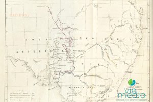
Charles Sturt Touring Route
Sturt's Loop — Broken Hill to Cameron Corner
The Charles Sturt Touring Route (Sturt's Loop) traces the approximate path of Captain Charles Sturt's 1844–45 Central Australian Expedition from Broken Hill, via Eldee Station (Silverton) or Mount Gipps Station, through Milparinka and Tibooburra to Cameron Corner. The full route is 635 km on maintained unsealed roads, recommended for 4WD or AWD vehicles in dry weather only.
Around forty years ago, I saw a video by Broken Hill identity Jack Absolom presenting what he referred to as 'In the Steps of Charles Sturt'. Jack's passion for the outback was evident, and it struck a chord with me immediately for a couple of reasons. His love of the outback was an inspiration to me as an aspiring photographer. His character and style was reminiscent of the rural characters I met as a teenager around our farm.
Additionally, I was always fascinated by Australian history, and hearing him speak about the explorer Charles Sturt (and others) motivated me to know more.
Fast forward to 2008, and I was lucky enough to have undertaken the following route while sourcing travel content. I would often mention this fantastic adventure from Broken Hill to Cameron Corner to others.
Sturt's Steps Touring Route — Overview
The following touring route follows the approximate route taken by Captain Charles Sturt during his 1844–45 inland expedition. With no public roads across the Barrier Ranges, we begin the journey further north than the line taken by the expedition.
Starting in Broken Hill, and travelling either via Eldee Station (Silverton) or Mount Gipps (Corona Road), to Milparinka then on to Tibooburra — which provides a great base for exploring Sturt National Park as well as a great touring route known as the Corner Explorer.
My preferred route is either:
- Eldee Station, Silverton → Packsaddle Roadhouse → Tibooburra → Cameron Corner.
- Mt Gipps Station → Packsaddle Roadhouse → Tibooburra → Cameron Corner.
Who Was Captain Charles Sturt?
Captain Charles Sturt was one of the most significant people associated with early Australia and the country's pre-eminent explorer.
Charles Sturt was born on 28 April 1795 in Bengal, India, and was the eldest of eight sons and one of thirteen children. At the age of four, he was sent to England to continue his education, and joined the British Army at age 18, serving in Spain, Ireland, Canada and France.
At the age of 22 (1827), he sailed to Australia as an escort to a shipment of convicts for Sydney, where he remained for several years.
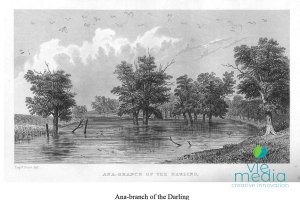
Charles Sturt and the Darling River
With a keen interest in exploring, Sturt's curiosity was piqued by Australia's unmapped interior and its waterways. Charles Sturt was appointed Private and Military Secretary to NSW Governor Ralph Darling, and led the 1828–29 expedition to trace the Macquarie River beyond its marshes. He discovered the Darling River, correctly deducing that the westward-flowing rivers were its tributaries.
In November 1829 Charles Sturt set out to further explore the western rivers and determine where the Darling River flowed. Darling hoped that the rivers drained into a fabled inland sea. His subsequent discovery of the Murrumbidgee–Murray–Darling river system, and his journey down the Murray to Lake Alexandrina and back, established him as Australia's pre-eminent explorer.
Charles Sturt served for a short time as Commander on Norfolk Island before returning to England, where he left the Army and married Charlotte Greene in 1834.
Sturt as a Pastoralist
In 1835 Sturt returned to New South Wales to take up his 5,000 acres of land granted for his military service. He failed as a farmer, and the overlanding of cattle from Goulburn NSW to the newly established colony of South Australia in 1838 was not a financial success either.
On their return from overlanding, Sturt wrote a detailed report which was published in the local paper. While in Adelaide he bought several blocks of land, did some surveying for the South Australian Company, and gained the position of Surveyor General from which Colonel Light had resigned. He left for Sydney where he arrived on 30 October.
In March 1839, while Sturt's brother Evelyn was involved in the overlanding of cattle (as was Henry Osborne), Charles Sturt and his family moved to South Australia to take up employment as Surveyor General. Unfortunately, Colonel Frome had been appointed to that job by the authorities in England, and he lost the position when Frome arrived in Adelaide.
Sturt and the Inland Sea
After the birth of his daughter on 19 January 1843 and having settled his family at the Reed Beds, Grange, Sturt once more took to exploring — this time to settle the debate about an inland sea in the centre of Australia. His party, which included John McDouall Stuart, left Adelaide in August 1844 and returned in January 1846. It had been a very difficult journey with temperatures often above 45 degrees Celsius.
Sturt failed to find the inland sea he had sought for so long, but did discover Cooper's Creek. Ultimately repelled by the dunes and gibbers of the deserts, he was forced to return to Adelaide due to scurvy and failing eyesight.
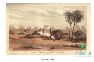
He was sympathetic to the Aboriginal peoples he encountered in all of his expeditions, realising that great changes to their way of life would result — an attitude he shared with his great friend and fellow explorer Edward Eyre.
When he finally reached the Stony Desert and the Simpson Desert he was convinced that there was no inland sea.
It was during this trip in 1845 that he discovered the Desert Pea near a creek which he named Cooper Creek after South Australia's Chief Justice Sir Charles Cooper.
Sturt's Grave in England
In 1847, Sturt returned to England, published his well-known Narrative of an Expedition into Central Australia, and returned to South Australia in 1849 as Colonial Secretary. However, in 1851, he retired to the Grange with a pension of £600 a year. Two years later, the family returned to England again due to poor health. Three of his sons then served in the Indian Army. Sturt died on 16 June 1869. Sturt Stony Desert, Sturt River and the Desert Pea are named after him in South Australia. New South Wales has honoured him with Charles Sturt University, and the Northern Territory with the Sturt Desert Rose.
Sturt's Central Australian Expedition 1844–1845
On 10 August 1844, Captain Charles Sturt led the Central Australian Expedition through the streets of Adelaide, then along the Murray and the Darling Rivers before heading where no European had been. The quest was to find the sea that Sturt and his sponsors believed occupied the heart of Australia.
The journey failed to find the mythical lake. Still, it ultimately led to the description and interpretation of vast areas of inland Australia, which would later be opened up for pastoralism and mining. The route through western New South Wales was significantly further than the shorter distance to the centre through South Australia. However, the commonly held belief was that a series of linked horseshoe lakes surrounded the northern reaches of the Flinders Ranges. By taking the eastern route the impenetrable sand dunes and the lakes would be avoided.
Crossing the Barrier Range
Charles Sturt was a careful explorer. The lives of sixteen men depended upon his decisions, the most critical being the location of water in a hostile, arid environment.
After leaving the relative safety of the rivers, Sturt travelled northwesterly across the plains from Menindee and set up camp amongst the hills to the east of present-day Broken Hill. Small survey parties of men were sent in search of routes across the ranges to the west, and to find waterholes where the expedition would be able to make camp.
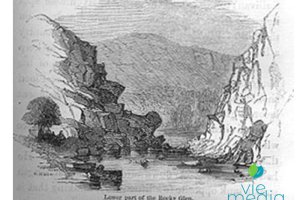
Once it was established that water was available, the expedition moved onwards, dragging carts and wagons laden with stores — and even a wooden boat to sail on the inland sea. They crossed the rocky gullies and narrow creek gorges of the Barrier Ranges until the expedition stood on the plain to the west, Mundi Mundi.
Moving to the North
Having struggled across the Barrier Ranges, a campsite was established near a gorge on west-flowing Campbell's Creek on the edge of the Mundi Mundi Plain. A day or so later another, further north — a soak-hole on Morphett's Creek — was reached.
There, from 29 November 1844, the group waited as two expedition members, James Poole and Harris Browne, travelled on horseback to the west toward Lake Torrens. Crossing sand dunes and salt flats, Poole and Browne rode until they were within sight of Mt Searle and Lake Blanch. Unfortunately, no route was found that would enable the expedition to continue safely in a westerly direction.
They followed their tracks back to inform Charles Sturt that the only option was to continue in the northerly direction. Robert Flood rode ahead to find the next campsite and discovered an excellent waterhole 70 km north on a creek that was later named Flood's Creek. After abandoning a dray in Morphett's Creek where it was bogged, they travelled on to Flood's Creek and set up camp for a week.
Poole, Browne and John Mack continued northwards as far as the Queensland border to search for and map the locations of further water supplies.
Sturt, John McDouall Stuart and Flood headed east across the Coko Range to the plains beyond toward the Nuntherungie Hills. Each party returned to camp on Christmas Day 1844, Sturt passing just to the south of Bancannia Lake.
With the weather increasingly hot and rainless, Sturt worried about water supplies drying up and was keen to keep moving. The expedition broke camp from Flood's Creek on 28 December. The wagons and carts struggled across the terrain of the Barrier Ranges. At the same time, Sturt rode to the Pinnacle Hill to the east, the most northern hill of the Barrier Ranges. From his vantage point, he could see the dust rising from the wagon wheels to the west.
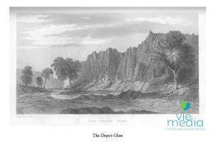
Depot Glen
To the north of the expedition route from Flood's Creek lies Mt Arrowsmith, a magnetic hill Sturt named after his London-based cartographer. The expedition travelled northeast across the southern slopes of Mt Arrowsmith and camped on a creek running to the east into Lake Bullea. Then, with the new year's temperatures in the extreme, the expedition continued northwards across Mt Browne Creek to Evelyn Creek, near where the township of Milparinka now sits.

At Evelyn Creek, the expedition set up camp while Sturt headed northwards into Queensland to the west of the Grey Range as far north as the Wilson River. Finding no water, they too returned to the safety of Evelyn Creek.
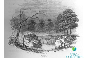
In Sturt's absence, other members of the group had discovered Preservation Creek, a tributary of the Evelyn, where a long sheet of water lay within a rocky glen and provided the possibility of water for almost twelve months. On 1 February 1845, the expedition relocated to this site. Named Depot Glen, it would become one of the most famous locations in Australian exploratory history. Without the possibility of retreat or advancement, the expedition remained entrapped at Depot Glen for almost six months.
The summer seemed relentless with temperatures exceeding 100°F for several weeks, and many members of the expedition party suffered from scurvy. An underground room was constructed in the bank of the gorge to offer relief from the heat and comfort to Poole, who was especially ill.
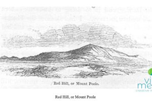
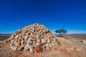
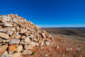
To relieve the monotony of camp life, Sturt's men walked daily to the top of the nearby Red Hill (Mt Poole), to construct a stone cairn, 21 feet square at the base and 18 feet high. It has become a memorial to Poole — the only expedition member not to survive.
Continuing the Quest
Sturt knew that it was impossible to move forward with the expedition, or even retreat, but was unable to rest. Taking three of his men with him, he again headed northwards across the border into Queensland. He followed his earlier trail but this time travelled further west of the junction of the Warri Warri Creek and Wilson Rivers.
Locating a westward-flowing creek (Frome's), he followed it to where it ended in Pinnaroo Lake. After the harshness of the country they had passed through before, Sturt found this locality far more favourable and named it The Park. Later the area would be called Fort Grey, after the Governor of South Australia.
Returning to Depot Glen, Sturt noted that many of the native birds which had frequented the waterhole had left — an ominous sign, he noted, of receding water supplies.
Within a few days Sturt and Browne headed off on a journey to search the country to the east of Depot Glen for water. They travelled almost 160 km to Yantara Lake but found nothing and returned to camp. Little wonder that Sturt was pessimistic — the future of the expedition seemed very bleak.
Periodically Depot Glen was visited by members of the local Aboriginal tribes. On one occasion, the arrival of an elderly man fuelled hope. Seeing the boat, and recognising its significance, the old man pointed towards the northwest — the very direction in which Sturt believed the inland sea lay — as if indicating a vast expanse of water.
Still, they waited, continuing to build the cairn, sending out small scouting parties to explore the wider area, and chaining a survey line of some 50 kilometres.
Release from Depot Glen
By June 1845 James Poole was desperately ill, and Charles Sturt began to make plans for him to be taken to Adelaide as soon as it rained enough. He was to be accompanied by five men, as well as one to nurse him during the journey. A unique bed of sheepskins was prepared on a cart, and letters were written to the South Australian Government requesting additional stores. Rain began to fall on 12 July, and two days later the creeks around Depot Glen filled with water.
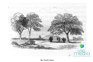
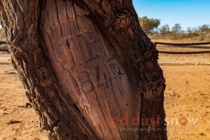
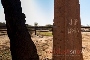
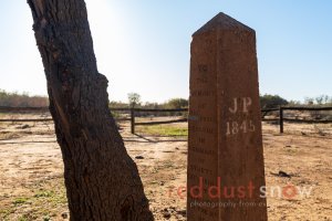
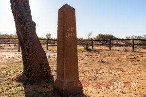
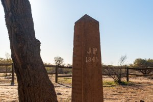
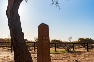
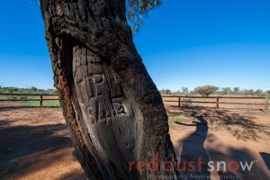
On 16 July 1845 the expedition left Depot Glen. Sturt's party moved along the survey line to the northwest; Poole and his carers along the southbound route. Sturt had travelled just six kilometres when a messenger from Poole's party rode up with the news that Poole had died. His body was returned to Depot Glen and buried nearby beneath a beefwood tree. Today it still bears the inscription carved into the bark: JP 1845. Remarkably he was the only man to die on the expedition, despite the conditions under which they travelled and lived. Others, including Sturt, also suffered terribly from scurvy, the heat and lack of water.
The day after the sad burial of Poole, the retreating party again set off for Adelaide. Sturt and his team also returned to their task of following their previously chained course to the northwest and continuing their expedition.
The intention was to set up a base camp at Fort Grey to explore a western route around Lake Torrens, allowing a route further north through what was already known to be very difficult country.
Beyond Fort Grey
While most of the remaining members of the expedition remained at Fort Grey to establish a stockade — and endeavour to germinate some of the seeds they carried with them — Sturt moved quickly to examine the country to the west of the South Australian border adjacent to Lake Torrens.
Finding no passage north of the sand dunes and lakes, he began his journey back to the fort on 5 August 1845.
Soon after, accompanied by Browne, Flood, Lewis and Joseph Cowley, Sturt again headed out for the northwest. With a massive effort across a barren, waterless landscape, the group reached their most northern point on the edge of the Simpson Desert on 8 September. Convinced that they could not continue toward the centre of Australia, they retreated to Fort Grey. Sturt then decided to take fresh men and scout to the north and east. This time he took just three men — Stuart, Mack and David Morgan — and followed their old course to Strzelecki Creek and on to Cooper Creek. Sturt had planned to go east along the Cooper, but rainfall in the area encouraged him somewhat, and the expedition turned to the north instead.
They dug wells to capture rainfall, but it was to no avail, and again they were forced to retreat. Returning to Cooper Creek, the party made one more desperate attempt to locate the inland sea and rode east along the Cooper until on 3 November they finally accepted the futility of their efforts. Sick and almost blind, Sturt retreated to Fort Grey.
The Retreat
Before leaving Harris Browne in charge at Fort Grey, Charles Sturt had given instructions that if they were forced to retreat from Fort Grey, they should fall back to Depot Glen. Upon return to Fort Grey, Sturt found that all had indeed left. Ill and disappointed, Sturt rode on to Depot Glen where the expedition was reunited.
Browne and Flood rode on to Flood's Creek in search of water and returned to Depot Glen with good news. Sturt instructed the men to kill four bullocks, and with their skins they made large water vessels. Leaving behind most of their stores — and the boat — they slowly began the long journey home. Too ill to ride his horse, Sturt was now uncomfortably confined to a bed on one of the drays.
The retreat was successful. Assisted by some wild berries found on bushes near Morphett's Creek, Sturt's health improved to the point that, on 19 January 1846, he rode into Adelaide and his home.
In Sturt's Steps Touring Route
- Total Distance: 635 km
- Road Type: Maintained unsealed road (dry weather only)
- Vehicle Recommendations: 4WD/AWD with clearance; 2WD with clearance and experience.
- Wet Weather Alternative: Silver City Highway
Despite the mention of Mundi Mundi (just west of Silverton) in accounts of the expedition, the published touring route of Sturt's Steps heads northeast from Broken Hill, then north at Corona Road to Mount Gipps Station.
For those interested in a more western route via Silverton and Mundi Mundi, please see Silverton to Cameron Corner Along the Dog Fence.
Sturt's Steps Route Detail
Via Silverton and Eldee Station (Total Distance: 578 km)
- Broken Hill to Eldee Station — 53 km
- Head out on Silverton Rd 23.75 km
- Silverton
- Continue onto Wilangee Rd 28.74 km
- Arrive at Eldee Station
- Eldee Station to Packsaddle Roadhouse — 294 km
- Head back to Wilangee Rd 1.2 km
- Continue along Wilangee Rd 26.9 km
- Slight right onto Wilangee Rd 25.5 km
- Turn left onto McDougalls Well Rd 17.8 km
- Turn left onto Corona Rd 23.8 km
- Continue onto Border Downs Rd 34.3 km
- Past Pine View Station
- Border Downs Rd 44.9 km
- Right onto Sanpah Rd 6.58 km
- Continue along Sanpah Rd 84.4 km
- Turn left onto Silver City Hwy 28.5 km
- Arrive at Packsaddle Roadhouse
- Packsaddle Roadhouse to Tibooburra — 200 km
- Head north on Silver City Hwy 33.9 km
- Turn left onto Mount Arrowsmith Rd 12.4 km
- Continue along Mount Arrowsmith Rd 46.7 km
- Past Pincally Station
- Head northwest on Mount Shannon Rd 13.2 km
- Keep left to stay on Mount Shannon Rd 52.8 km
- Arrive Milparinka
- Continue straight onto Milparinka Rd 1.46 km
- Turn left onto Silver City Hwy 39.9 km
- Arrive Tibooburra
Via Mt Gipps Station (Total Distance: 578 km)
- Broken Hill to Mt Gipps Station — 41 km
- Head north via Silver City Hwy 30.92 km
- Turn left onto Corona Rd 8.61 km
- Turn right 1.23 km
- Arrive at Mt Gipps Station
- Mount Gipps Station to Packsaddle Roadhouse — 285 km
- Head northwest along Corona Rd 86.6 km
- Continue along Border Downs Rd 34.3 km
- Past Pine View Station
- Border Downs Rd 44.9 km
- Right onto Sanpah Rd 6.58 km
- Continue along Sanpah Rd 84.4 km
- Turn left onto Silver City Hwy 28.5 km
- Arrive at Packsaddle Roadhouse
- Packsaddle Roadhouse to Tibooburra — 200 km
- Head north on Silver City Hwy 33.9 km
- Turn left onto Mount Arrowsmith Rd 12.4 km
- Continue along Mount Arrowsmith Rd 46.7 km
- Past Pincally Station
- Head northwest on Mount Shannon Rd 13.2 km
- Keep left to stay on Mount Shannon Rd 52.8 km
- Arrive Milparinka
- Continue straight onto Milparinka Rd 1.46 km
- Turn left onto Silver City Hwy 39.9 km
- Arrive Tibooburra
From Pine View Station, the touring route continues north along Border Downs Road, crossing Packsaddle Creek before heading back southeast along Sanpah Road.
It should be noted that the actual route Sturt took was more northeasterly, through what is now Pimpara Lake Station and Pincally Station. With Sanpah Road roughly the midpoint to Cameron Corner (as the crow flies), there is an excellent option east to the Silver City Highway and one of the best roadhouses in Australia for a meal, refreshments, and great hospitality at the Packsaddle Roadhouse.
After visiting Packsaddle Roadhouse, the route continues north along the Silver City Highway 34 km, then west along Mount Arrowsmith Road via Pincally Station, passing Mt Arrowsmith, Mt Shannon and Mt Browne before reaching Milparinka.
Milparinka and Surrounds
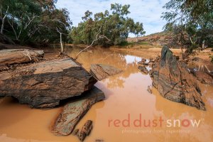
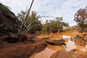
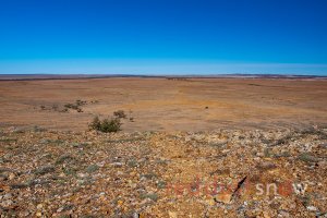
Milparinka is one of only two townships surviving in the Corner Country — the other being the larger community of Tibooburra — and is 296 km north of Broken Hill, 39 km south of Tibooburra, and 1,465 km from Sydney. All around, the red dusty soils of Outback New South Wales stretch to the horizon. Gold was discovered in 1880, and Milparinka became a thriving town, but today it is a shadow of its former self — a reminder that only the hardiest of people can live in such severe conditions.
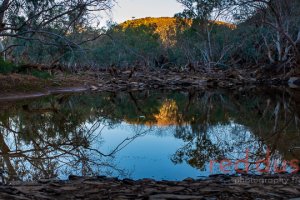
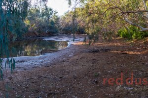
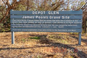
Not far from Milparinka along the touring route is an area that provides great insights into Sturt's expedition: Depot Glen, Poole's Grave and Mount Poole — 13.9 km west of Milparinka via Hawker Gate Road.
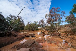
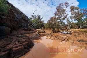
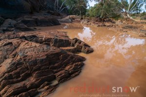
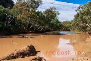
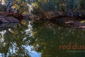
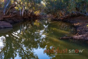
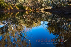
Depot Glen and Mt Poole
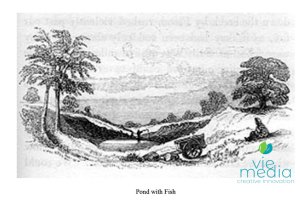
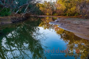
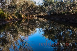
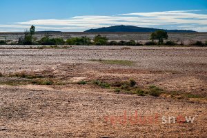
Depot Glen, on Preservation Creek, was the base camp for Charles Sturt's expedition party for six months — unable to move forward or backward because of extreme heat and drought. The explorers constructed an 'underground room' in Depot Creek, a tributary of Evelyn Creek, where there was a permanent waterhole. Having access to this water, they survived the drought.
While the leading group of Sturt's expedition pushed north, a second group stayed at Depot Glen waiting for their return. To keep the men busy, Sturt had them walk to Red Hill (Mt Poole) each day 'to give the men occupation and keep them in health', where they constructed a cairn.
James Poole, the second in command, died of scurvy on this expedition and was buried near Depot Glen. A beefwood tree with his initials carved in the bark marks the grave.
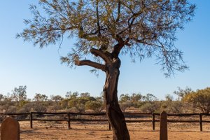
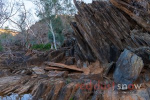
The only trees on the gibber plains in the vicinity of Mt Poole are river red gums lining the beds of the ephemeral streams. In the deeply incised bed of Depot Creek, the tree roots reach down to the water that flows beneath the surface along the stream beds.
After visiting Poole's Grave, Depot Glen and Mt Poole (Red Hill), the adventure continues back at Tibooburra — about 55 km back up the highway — the perfect base to explore the Corner, including the drive to Cameron Corner!
With Tibooburra as a base, it is time to explore the region, and there are several great touring experiences along with the Cameron Corner Explorer.
Sturt's Loop Touring Guide
Sturt's Loop Touring Route Brochure — coming soon. The touring guide is regularly updated — sign up to keep your map up to date!
Frequently Asked Questions
What is the Charles Sturt Touring Route (Sturt's Loop)?
The Charles Sturt Touring Route — also called Sturt's Loop — is a 635 km self-drive adventure from Broken Hill to Cameron Corner that traces the approximate path of Captain Charles Sturt's 1844–45 Central Australian Expedition. It runs via Eldee Station (Silverton) or Mount Gipps Station, through Pine View Station, Packsaddle Roadhouse, Milparinka and Tibooburra to the Corner.
Do I need a 4WD for Sturt's Loop?
A 4WD or AWD with good ground clearance is recommended. The route is on maintained unsealed (dry weather only) roads. Two-wheel-drive vehicles with clearance and experience can complete the route in ideal conditions, but if rain is forecast you should take the sealed Silver City Highway alternative instead.
What is Depot Glen and why is it significant?
Depot Glen, on Preservation Creek near Milparinka, was the base camp for Charles Sturt's expedition for almost six months in 1844–45. Trapped by extreme heat and drought with no water to retreat, the explorers built an underground room for shelter and kept busy constructing a cairn on the nearby Red Hill (Mt Poole). It is one of the most famous locations in Australian exploratory history.
What is the wet-weather alternative to Sturt's Loop?
When unsealed roads are closed after rain, the Silver City Highway is the sealed all-weather alternative for reaching Tibooburra, though the final 120 km from Tibooburra to Cameron Corner remains unsealed.
Who was James Poole and where is he buried?
James Poole was the second-in-command of Sturt's 1844–45 expedition. He died of scurvy at Depot Glen on 16 July 1845 and was the only expedition member not to survive the journey. He is buried near Depot Glen beneath a beefwood tree, with his initials JP 1845 still carved in the bark.
Explore the Corner Country
Sturt's Loop is one of the most historically rich routes in outback Australia. Pair it with the Corner Explorer touring route from Tibooburra, or explore the Dingo Fence route for a different adventure.
Corner Explorer Touring Route The Dingo Fence Route Outback Wall Art